|
Overview of maps and a number of pictures
Here you will find an overview of the maps used on this site.
Click on the thumbnail. It takes some time before some of these maps
are loaded so be patient please, hit the back button the return to
this page click on the thumbnails to see the map or picture Most of
these maps have been edited and completed with a signature for copyright
reasons. In this place I want to thank the department of Cartography
of the University of Utrecht, especially Peter van der Krogt, their
great reception and the help in making images made with an electronic
camera. Without their help these pages wouldn't exist!
After la Perrouse went to chart the sea to the north of Japan, he
called it the Japanese Sea or some such - that was in 1786 or 1787.
His journal was quite popular, so the name might have been picked
up by the rest of Europe. For more 17th century maps and engravings,
follow the link at the bottom of the page
|
 Be patient, it takes some time to download this map. According to
the preface, this Korean map (known as the Kangnido) was made by Yi
Hoe and Kwon Kun in 1402. This copy from ca. 1470 is the oldest surviving
world map from East Asia. The map has clear outlines of Africa and
the Arabian Peninsula, with India coming out of the general Chinese
continent. On the far right is the greatly magnified Korean peninsula
with the Japanese islands directly below. The west of Japan
is oriented west at the top. Kangnido Honil Kangni Yokdae Kukdo Chido
(Map of the integrated lands and regions of historical countries and
capitals
Be patient, it takes some time to download this map. According to
the preface, this Korean map (known as the Kangnido) was made by Yi
Hoe and Kwon Kun in 1402. This copy from ca. 1470 is the oldest surviving
world map from East Asia. The map has clear outlines of Africa and
the Arabian Peninsula, with India coming out of the general Chinese
continent. On the far right is the greatly magnified Korean peninsula
with the Japanese islands directly below. The west of Japan
is oriented west at the top. Kangnido Honil Kangni Yokdae Kukdo Chido
(Map of the integrated lands and regions of historical countries and
capitals
|
 Iaponiae insulae descriptio / Ludoico Teisera auctore. Scale [ca.
1:4.750.000]. [Antwerp : Plantijn, 1595]. 1 map : copperengraving
; 32 x 45 cm, Cum Imperatorio, Regio, et Brabantiae privilegio decennali.
1595. Verso: French text from: Théâtre de l'Univers 1598. Van den
Broecke, Ortelius atlas maps 165.1; Karrow, Mapmakers sixteenth century
1/198; Koeman, Atlantes Neerlandici Ort 28 [134], Meurer, Fontes 134.
It took a long time before the region was "decently" mapped,
both position and shape. Since the middle-ages Japan
was depicted as Chipangu or Zipangu. The Portuguese
reached Japan in 1542. Till in 1641 all foreigners, except the Dutch,
had to leave the country missionaries offered the most cartographic
information about the country. The data from the Jesuits was accordingly
revised by the official Portuguese cartographs, like Fernao Vaz Dourado.
He gave Japan the shape of the back of a tortoise, like it was depicted
already in the second half of the sixteenth century. Thanks to the
close contacts between Ortelius with Luis Teixeira, the most modern
map in 1595 was added to the Theatrum, the orientation of the island
Honsyu is not optimal yet, but the shape, now probably derived form
autochthonous examples, has made a considerable improvement. Korea
is already mentioned, be it as an island. The changes went that fast
that in the same period several anachronisms co-existed. On the small
worldmaps and the maps of Asia the 16th shape is still to be seem
while Jan Huygen van Linschoten in his Itinerario
from 1595 the traditional shape of Vaz Dourado shows.
Iaponiae insulae descriptio / Ludoico Teisera auctore. Scale [ca.
1:4.750.000]. [Antwerp : Plantijn, 1595]. 1 map : copperengraving
; 32 x 45 cm, Cum Imperatorio, Regio, et Brabantiae privilegio decennali.
1595. Verso: French text from: Théâtre de l'Univers 1598. Van den
Broecke, Ortelius atlas maps 165.1; Karrow, Mapmakers sixteenth century
1/198; Koeman, Atlantes Neerlandici Ort 28 [134], Meurer, Fontes 134.
It took a long time before the region was "decently" mapped,
both position and shape. Since the middle-ages Japan
was depicted as Chipangu or Zipangu. The Portuguese
reached Japan in 1542. Till in 1641 all foreigners, except the Dutch,
had to leave the country missionaries offered the most cartographic
information about the country. The data from the Jesuits was accordingly
revised by the official Portuguese cartographs, like Fernao Vaz Dourado.
He gave Japan the shape of the back of a tortoise, like it was depicted
already in the second half of the sixteenth century. Thanks to the
close contacts between Ortelius with Luis Teixeira, the most modern
map in 1595 was added to the Theatrum, the orientation of the island
Honsyu is not optimal yet, but the shape, now probably derived form
autochthonous examples, has made a considerable improvement. Korea
is already mentioned, be it as an island. The changes went that fast
that in the same period several anachronisms co-existed. On the small
worldmaps and the maps of Asia the 16th shape is still to be seem
while Jan Huygen van Linschoten in his Itinerario
from 1595 the traditional shape of Vaz Dourado shows.
|
 Maker Ortelius Title Iaponia Insulae
Descriptio Influential map of Japan, based on the work of the Jesuit
Ludovico Teixeira. The map is the first reasonably accurate and recognizable
European depiction of Japan and was to remain
the standard for more than half a century. Little was known of this
mythical and remote island. Korea is shown as an island and even less
was known about it. Three decorative ships and two cartouches.
Maker Ortelius Title Iaponia Insulae
Descriptio Influential map of Japan, based on the work of the Jesuit
Ludovico Teixeira. The map is the first reasonably accurate and recognizable
European depiction of Japan and was to remain
the standard for more than half a century. Little was known of this
mythical and remote island. Korea is shown as an island and even less
was known about it. Three decorative ships and two cartouches.
|
 This map of Japan (1606) by Dutch cartographer
Jodocus Hondius predates the establishment of the Dutch and English
factories in Kyushu and is thus based on Portuguese sources. The forms
of the three large islands (Honshu, Kyushu, and Shikoku) are discernible,
but it would be some time before the questions surrounding the northern
island of Hokkaido were resolved. Here Korea is shown as an island,
really different then it's original shape, these three maps, are remarkably
alike
This map of Japan (1606) by Dutch cartographer
Jodocus Hondius predates the establishment of the Dutch and English
factories in Kyushu and is thus based on Portuguese sources. The forms
of the three large islands (Honshu, Kyushu, and Shikoku) are discernible,
but it would be some time before the questions surrounding the northern
island of Hokkaido were resolved. Here Korea is shown as an island,
really different then it's original shape, these three maps, are remarkably
alike
|
 L'ASIA 1677 copper engraving with later color
|
 IL REGNO DELLA CHINA 1682 copper engraving with later
color
IL REGNO DELLA CHINA 1682 copper engraving with later
color
|
 Pieter Schenk and Gerald Valck
NOVA ET ACCVRATA IAPONIAE TERRAE ESONIS c.1700
copper engraving with original color
|
 This map (1713) by Pieter van der Aa shows the long and circuitous
voyage of the first English expedition to Japan
a century earlier. Van der Aa was part of the Dutch colonial establishment
in Java and produced an atlas of remarkable European voyages of discovery;
this map is from that atlas.
This map (1713) by Pieter van der Aa shows the long and circuitous
voyage of the first English expedition to Japan
a century earlier. Van der Aa was part of the Dutch colonial establishment
in Java and produced an atlas of remarkable European voyages of discovery;
this map is from that atlas.
|
 Spectacular carte-a-figures map of China, with 4 views across top
and 8 costumed figures. Shows Great Wall, Japan, Korea as an Island,
etc. Shows cities, rivers, lakes, mountains, topographic detail, etc.
2 cartouches, sailing ships and sea monsters. Here Korea is also shown
as an island, must be made around the same time as the map of Jodocus
Hondius at least before Hamel wrote his Journael.
Spectacular carte-a-figures map of China, with 4 views across top
and 8 costumed figures. Shows Great Wall, Japan, Korea as an Island,
etc. Shows cities, rivers, lakes, mountains, topographic detail, etc.
2 cartouches, sailing ships and sea monsters. Here Korea is also shown
as an island, must be made around the same time as the map of Jodocus
Hondius at least before Hamel wrote his Journael.
|
 Quelpaert as described by the French expedition of la Perrouse in
1787. It's one of the first Western maps of the island
Quelpaert as described by the French expedition of la Perrouse in
1787. It's one of the first Western maps of the island
|
 The isle of Ullûngdo, named by De La Perouse as Dagelet, a name
still in use by the foreign countries in 1946 as can be seen at my Cartography
site
The isle of Ullûngdo, named by De La Perouse as Dagelet, a name
still in use by the foreign countries in 1946 as can be seen at my Cartography
site |
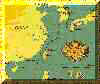
 An 18th century Korean map of Cheju -do and a
new explanation where the ship was wrecked.
An 18th century Korean map of Cheju -do and a
new explanation where the ship was wrecked.
|
 Here you can see that Tayoan is Tainan
|
 Here you can see the location of Fort Zeelandia
in Tainan
Here you can see the location of Fort Zeelandia
in Tainan
|
 This is Taiwan in 1860, with the location of the ruins of the Dutch
fort Zeelandia
This is Taiwan in 1860, with the location of the ruins of the Dutch
fort Zeelandia
|
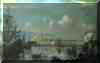
 This is a view at fort Zeelandia in Tainan, Taiwan:
|
 17 th Century painting of Fort Zeelandia
|
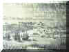 Chinese rendering of Fort Zeelandia
|
 West Africa, the map speaks for itself, it's rather big, the relevance
here is that the Dutch harboured here, in order to take food.
West Africa, the map speaks for itself, it's rather big, the relevance
here is that the Dutch harboured here, in order to take food.
|
 This is another French map of Korea, undated, but considering the
names, might be made shortly after the expedition of de la Perouse
had published his maps.
This is another French map of Korea, undated, but considering the
names, might be made shortly after the expedition of de la Perouse
had published his maps.
|
 A pretty modern map of Korea and Japan before
1880
A pretty modern map of Korea and Japan before
1880
|
 A map of Asia of 1808
|
 A map of Asia of 1859
|
 Deshima , an artificial island near Nagasaki,
the place where the Dutch were allowed to live and do trade with Japan.
Hamel eventually escaped from Korea to this island and here he wrote
his Journael, there is another one for the Chinese enclave,
these were in the books written by Isaac Titsingh, Embassador to China
and Opperhooft in Deshima.
Deshima , an artificial island near Nagasaki,
the place where the Dutch were allowed to live and do trade with Japan.
Hamel eventually escaped from Korea to this island and here he wrote
his Journael, there is another one for the Chinese enclave,
these were in the books written by Isaac Titsingh, Embassador to China
and Opperhooft in Deshima.
|
 Example of a hand-drawn chart like they were used in the 17th century
on board of the VOC-ships.
Example of a hand-drawn chart like they were used in the 17th century
on board of the VOC-ships.
|
 The
route of the crew of the Sperwer can be seen here. This beautiful
semi-old map is made by Jan Boonstra The
route of the crew of the Sperwer can be seen here. This beautiful
semi-old map is made by Jan Boonstra
|
 Modern map of Korea with the route Hamel took on mainland Korea to
Seoul and back
Modern map of Korea with the route Hamel took on mainland Korea to
Seoul and back
|
 Songnam, another name for Pyongyong where Hamel
and his men lived for 8 years, probably married and had families.
Songnam, another name for Pyongyong where Hamel
and his men lived for 8 years, probably married and had families.
|
 1. Location of the Hamel monument. 2. Kapado (according McCune Reisschauer:
Kap'ado). 3. Marado 4. Taejong To give an idea of the distances: the
distance from Kapado to the coast of Cheju is
about 4 km. (Taejong - Hamel monument = 6.5 km). Since new evidence
showed up, the map is in fact obsolete, but a new map and explanation
are added to the 17th century map of Cheju-do.
1. Location of the Hamel monument. 2. Kapado (according McCune Reisschauer:
Kap'ado). 3. Marado 4. Taejong To give an idea of the distances: the
distance from Kapado to the coast of Cheju is
about 4 km. (Taejong - Hamel monument = 6.5 km). Since new evidence
showed up, the map is in fact obsolete, but a new map and explanation
are added to the 17th century map of Cheju-do.
|
 This is the province of Cholla -do
|
 Korea in the time of the three kingdoms.
|
 Korea in the time of Shilla and Parhae.
|
 Korea in the time of Koryo, from this name the name Korea is derived.
|
 Korea nowadays.
 Back to previous page
 |
For more maps  |
|
 |
 |


